
Skies over the UK have taken on a milky, slightly muted look this week — and the cause is thousands of kilometres away, in the burning forests of central Canada. Smoke from one of the country's worst fire seasons on record has ridden the jet stream across the Atlantic and is now sitting high over Britain and much of western Europe.
A continent-scale fire season
Canada is battling an extraordinary summer of fire. As of mid-to-late July 2026:
- The Canadian Interagency Forest Fire Centre reports over 850 active wildfires, concentrated across Manitoba, Saskatchewan and Ontario — most of them completely uncontrolled.
- Ontario alone had 193 active fires burning around 1.7 million acres (roughly 673,000 hectares) as of 17 July.
- The smoke has driven historic air pollution across the US Midwest and Northeast. Duluth, Minnesota hit an air-quality index of 934 for fine particulates — shattering its previous record — and on 16 July Detroit briefly ranked as the most polluted major city on Earth.
Forecasters have called it the most significant smoke-pollution event to hit that part of the continent since the extraordinary 2023 season.
The mechanism: how the smoke reaches Britain
Getting smoke from a forest fire in Manitoba to a sunset over Scotland is a textbook piece of long-range atmospheric transport. It happens in three stages.
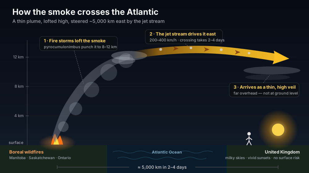
Figure 1 — The smoke never travels down at our level. It is lofted high, driven east by the jet stream, and arrives thinned out and far overhead.
1. The fires build their own weather
A large, intense wildfire does more than burn — it generates a towering column of super-heated air. When that rising air carries enough moisture it forms pyrocumulus and, in the most violent cases, pyrocumulonimbus clouds: fire-driven thunderstorms that punch smoke and soot straight up through the lower atmosphere. This can inject particles to 8–12 km, close to the cruising height of an airliner and right up near the top of the troposphere.
2. The jet stream does the driving
At that altitude the smoke meets the jet stream — a narrow, fast river of air that flows west-to-east around the mid-latitudes at 200–400 km/h. It is the same current that steers our Atlantic weather systems onto the UK. Because the smoke is sitting above most of the day-to-day weather, very little of it gets rained out or mixed down on the way. The plume can cross the roughly 5,000 km of ocean in just two to four days, arriving largely intact.
3. It arrives as a thin veil, not a pall
By the time the plume reaches the UK it has spread and diluted into a thin, optically-faint layer high overhead — nothing like the choking ground-level smog experienced downwind of the fires in North America. You can often only detect it by the colour it lends the sky, or in satellite imagery.
What you will actually notice
For chasers and sky-watchers, this is a photography story, not a health one:
- Milky, whitened-out blue skies and a slightly muted sun by day.
- Vivid red and orange sunrises and sunsets, as the low sun angles through the smoke layer.
- A subtle haloed or dirty look to the sun near the horizon.
Because the smoke sits so high in the atmosphere, the Met Office has been clear in previous episodes that it poses no meaningful risk to surface air quality. Enjoy the sunsets.
Why the colours?
Sunlight is a mix of all colours, but the air — and the smoke suspended in it — scatters the shorter blue and violet wavelengths far more strongly than the longer red and orange ones. At midday the sun is high and its light takes a short path to your eye, so the effect is mild. At sunrise and sunset the sun sits low on the horizon, and its light has to travel a long, slanted path through the atmosphere and the extra smoke layer. Over that distance almost all the blue is scattered away, leaving the reds and oranges to reach you — which the wildfire particles exaggerate into unusually deep, fiery skies.
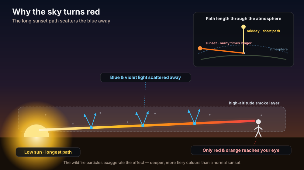
Figure 2 — Why the sky turns red: the long, slanted sunset path scatters out the blue and leaves the reds, deepened by the smoke.
A recurring summer visitor
Trans-Atlantic smoke like this has become an almost-annual feature of a warming boreal summer. Plumes reached north-western Europe in June 2025 (confirmed by the Copernicus Atmosphere Monitoring Service), red-tinted skies spread across the UK during the record 2023 Canadian season, and the phenomenon has been documented as far back as the 1950 Great Smoke Pall. What sets this episode apart is the sheer scale of the fires feeding it.
So if your evening sky looks strangely amber this week, you are looking at the tail end of a continent-scale fire season — carried five thousand-odd kilometres on the jet stream, and completely harmless by the time it reaches us.
Grab a camera. The best colour is in the twenty minutes after sunset.
Discussion · 0
Sign in to commentNo comments yet — be the first.
Members can post. Sign in to join the discussion.